I am preparing for the long awaited trip West, returning my Brothers ashes to New Mexico. A simple request he made. A promise I have ached to fulfill. In these 2 weeks prior to departure, He is hourly on my mind. Though I've returned to my normal life, it still feels raw.
When my Brother came to live with us we had to make some changes in our old farmhouse. My husband and I had always slept downstairs in the smallest bedroom, leaving the upstairs bedrooms for our collection of in and out kids. Our house was built in 1869 and in tradition with that era, the staircase is steep. To accommodate his declining status, we moved upstairs and we made our previous bedroom into his room. There is a fireplace in there and designed to give him privacy and the best access to the bathroom. The last 3 weeks of his life, I slept on a loveseat just outside his doorway. After his death I stood in that room, now empty of a hospital bed and other implements of his illness, and thought, I'm done here. I cleaned it up, turned on a lamp and walked away. I thought it best.
Today my Husband and I went shopping for a new box springs and mattress. We picked out a nice one after laying on every mattress in the store. My husband looked at me after we arranged for delivery and said "Little (He has always called me that and I'm not sure he knows my real name), I think its time to move back downstairs". He is right. I have prepared our bedroom for delivery Monday. I'm sitting on the same loveseat where Ive read for years while my Husband watches ballgames. Our life will return to where it was before. My Brother would approve. He was clear that there be no "shrine". He referred to me as "useful and decorative" when I cared for him during his illness. I honor him by going home. Even if its just to my bedroom.
Lastly, I checked my Brothers email and facebook today. It had been about a month since I did so. There was a facebook message to him from an old friend. She missed him. I miss him too.
Click photograph to view large formatted image
Saturday
Sunday
Time passages
Its been 2 months and a day since my Brothers physical presence exited. Some days it feels like yesterday and other days it feels a lifetime ago. I have spent time returning to my deliberate life. I take care of our Mama, I work in the Emergency Department at a local hospital, I am a Wife, Mother and Grandmother. All those things are good for me. They are my purpose. But I have a promise I made, not yet kept. To my only Brother. I promised to take him home.
This promise is important. I want to do it and I will. I have the plans made. I have a departure date. I'm going. My problem is, historically, I'm a runner. When life overwhelms me, I run. Its usually post crisis and really has never served me well. I have certainly learned as an adult to control this. I've had a successful career. Raised a house full of kids, not all I gave birth to and have a long committed relationship to my Husband. Who knew at this point in my life, the urge to run would come back in full force?
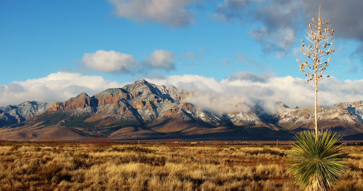
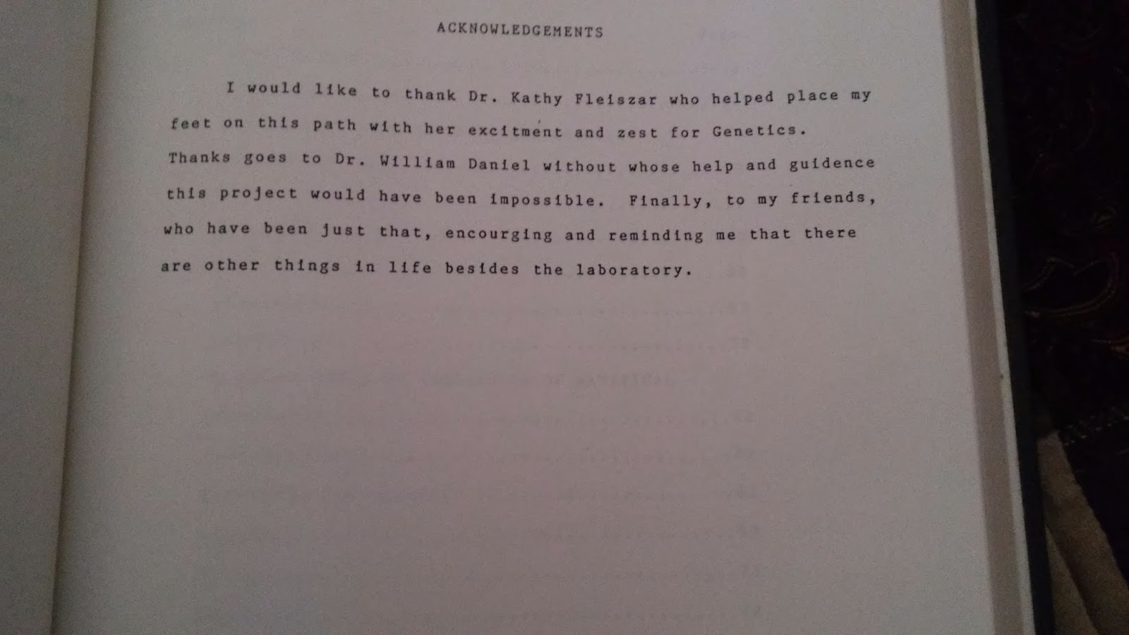
As I've struggled daily to keep myself in check, I've dreamed of my Brother's bubble. His life in the desert where he felt safe and accepted. A recent browse through his possessions, I came across his dissertation. Written on a Commodore 64, completed in 1987. Above is his acknowledgement. The people specifically mentioned, he valued so intensely. One even visited him in our home in his last days. It was extremely meaningful to him. Its that last sentence that caught my eye. His friends. Those people who taught my brilliant brother that there was more than the laboratory. Those friends that taught him it was ok to run. And run, he did. I'm grateful to them for what they taught him. It was a life fulfilled.
So I've put my gypsy soul in order. I will run, the end of May. I will fulfill my promise. I will take my Brother home. I will return to my own bubble where I know, there is nothing to run from.
Friday
Its not goodbye

My brother died Sunday morning. I was alone with him, at his bedside when the end came. The week before had been tumultuous. There were episodes of restlessness and pain that required constant physical care. On Wednesday, he asked for Last Rites. Following a very moving time with our Priest, Mama and my girls, he went to sleep. From then on, He never spoke. I performed his physical care, slept at his bedside and waited. On Friday night, an ice storm came. For those familiar with this part of the country, ice is rare but snow is common. We live quite rural and access to us became limited. My Husband, in a desperate attempt to help, began salting. Our drive, our deck and sidewalks.
Saturday came and went. I turned him every couple of hours, did oral care and kept him clean. He did not respond at all.
Sunday morning at sunrise, I awoke from my station on the couch to see the sun coming through the window in a bright ball of light over my brothers bed. My husband and I previously occupied that room and is all our years there, I had never seen such a thing. I snapped a photo and began to care for my Brother. I was tired, scared and a little bit crazy. I defaulted to what I knew. Nursing.
At 0930 my Husband ventured out for "fancy" coffee. He's a kind man and wanted me to feel better. The icy roads were not going to stop him.
I sat down at my Brothers side. His eyes closed with no response for days. He was clean, dry, carefully positioned (I used 9 pillows). At about 10, He opened his eyes and turned his head and looked at me. Startled, I asked him "are you in pain"? He didn't answer but slowly closed his eyes and took his last breath.
It was peaceful, quiet and over.
I spent about 30 minutes alone with him. It was the greatest gift. I knew the days and moments following would be hard. I took that time, I believe, God given, and relived our life as only siblings. He was important to me.
There has been some humor that I'm sure my Brother orchestrated. Hospice couldn't make it out after his death, due to icy roads. Our local coroner, accepted my pronouncement of his death as I am a nurse (finally that ER experience came in handy). The funeral home was delayed, also due to icy roads. My husband and I enjoyed "fancy coffee" and muffins with my Brother's remains. After all, food was a quality factor for him.
So, its not goodbye. There's more to this journey. The cancer part is over. I await his ashes, which I'll store til Spring. He was very clear that I not make a shrine, so I imagine I'll keep them in a cabinet. Then off to New Mexico at first weather break.
I'll post here on occasion. The transcripts of this journey as well as my personal journal and notes from our Hospice nurse and Priest will eventually go to an copy editor for publication. It was my Brothers final hope that someone else could learn from his journey. Typical B Alvarius fashion
Thursday
Morning has broken
My Brother hasn't moved or spoken since yesterday at 1pm. The stillness is peaceful. After the restless, painful, scary Tuesday and into early Wednesday, I feel God's mercy. Not as I pictured it but peaceful just the same. I listen to his breathing now, not with fear of his last breath. I slept on the love seat restfully. I woke up twice in the night to stillness. Just the sound of him breathing.
I thought I'd made friends with the pain of my Brother dying. I fought it pretty hard though. My words to myself in journal form have helped, but as I reread them now I see the complicated, controlling journey I chose..
I'm a tough cookie, I've always told myself. I don't throw my hands up. I don't take to my pallet. I have endurance and stamina and I don't throw pity parties. I always try to do whats right and I think of others first. These are my conscious values. I thought heading into this I had what I needed to be with my Brother every step of the way. I did but after much struggling I find that I need God's Grace.
I am aware now that Grace will peacefully do the rest.
I'm not throwing my hands up. I am folding them in surrendered prayer.
Please join me.
Wednesday
The Rally: A nonclinical perspective

When our Priest arrived Monday morning, expecting to deliver last rites, my Brother was pirouetting in his wheelchair in the living room. They spent time together, discussed literary collaborations and prayed.
So the rally I looked for, came. It appeared in the form of one of his original goals: food.
It didn't last but it was tremendously entertaining and I had a peek again at my strange and wonderful Brother.
Pain is now the issue. He does get up in his wheelchair briefly several times a day. Not really for food or drink now but for the occasional cigarette. Hospice nurses felt that as his metabolic needs decreased, so did his need for meds and we attempted a 6 hour regimen. That turns out not to be the case. Nights are long and painful and we spend them trying to catch up. I am giving him morphine now, when he asks. Time increments really don't matter. He sips water or juice boxes but really still has no measurable intake. He wanted to go to the bathroom yesterday and we wheeled him in at which point he promptly fell in the toilet. He weighs 114 lbs.
I'll not speculate, even in my mind, about the next post. I will certainly commit to keeping his readers informed.
Saturday
Little Sister

At 0845, I woke him. He never opened his eyes but took his meds. I asked him if he wanted to get up, and there it was, the look. He opened his eyes and mumbled something. I didn't need the words, I remember the look. I'm 9, he's 12 and I've invaded his space. He is busy doing something and I've got questions. Way too many questions. The look isn't mean, its actually gentle, but I remember it. "go away, come back later".
The nurse in me said "still his little sister".
I wouldn't have it any other way.
Thursday
Its his Sister. For those who wait, we can feel you. Time has been precious and cruel. The earth suit is failing and the ability to type and express thoughts currently exceeds his capabilities. I keep waiting for one of those beautiful "rallies". One where he is standing at the kitchen counter eating a cinnamon roll with a sparkle in those blue eyes. He seems fairly comfortable though the physical ravages are obvious. When he's sleeping, which is a lot, I like to think he soaring through the desert and those mountains in his ultra lite. I picture him safe, healthy and strong in that "bubble". In the meantime, we are with him.
I'll update here as I can. I find strength in his readers.
I'll update here as I can. I find strength in his readers.
Let's Make a Deal – Bargaining with the Unknown
As the more emotional aspects of my
personality continue to exert themselves I notice the bargaining
process beginning. Discussions with the blg misty unknowable on how
to avoid upcoming events. Today was particularity emotional since I
was able to visit with my old undergraduate professor and mentor from
the 1980's who I had not seen in about a decade. She was in Chicago
for the holidays and made a special trip down to visit. I of course
cried like a baby at her embrace and we were able to visit for
several hours. A major highlight in my day and one I will not forget
(literally take to my grave). I appreciated her visit so much and
because of her compassion I made through graduate school with a
freshly minted PhD many years ago.
My mother came by in-preparation for a
visit by Father Mark who administered communion. This was primarily
for her benefit but got me tracking on the bargaining process and
reinforced the notion that much of this process is about others and
my job is to muddle through the tears as best as I can.
ic
You knew, the why me, not now, I did
everything according to the book, don't I get a pass? But no, I
don't get a pass and like everyone else walks this road alone but
surrounded by friends and family.
At this point I don't i'm not sure how
I feel about the traditional death watch and must confess a certain
ignorance about the process, so I guess some study is in order.
Questions like who should be around
, do the kids participate? How boring
is the process? Will there be games? I just don't know at this point
and perhaps I can evade the question altogether.
As I speak with others who have
traveled this road with others i'm amazed at the detailed personal
stories and accumulated wisdom i'm hearing but have yet to find a
good distillation, so i'll just keep looking.
Tuesday
A Breast
As I watch certain physiological
aspects of my male body change in prepration for shut down I also
notice other aspects become hyper accentuated. One particular image
will not seem to leave my mind, a typically male response, it is an
image of a breast, a right breast belonging to a friend.
I first glimpsed this right Brest back
lite by the sunlight through a tee shirt. The warm glow of the late
summer afternoon light highlighted in shadow the perfectly rounded summitry of the Brest, taught within the confines of the teeshirt and
the image lives on randomly popping in my mind like random bits of
floatsom at any opportunity. Although the other physiological
responses that usually accompany a magnificent site have eluded me,
this vision of grandeur stays with me. The edge of the nipple just
peaking out from the white teeshirt in the warm summer afternoon will
not soon leave me.
A some what bohemian observation and I
hope not offensive.
Thursday
Expectations versus reality
The idea of hospice congers up a whole range of ides from "giving up on life" to " transitioning and exiting life in the best manner possible". Excluding tramatic injury where triage protocols take precedent, the slower decline where hospice intervention can be of utility actually applies to all of is as we age. So it seems that hospice care of some sort is a useful tool for all to be
ware of. While I can only comment from an N=1, and I have found the first line of defense more than sufficient in pain control. That is not to say that there are not periods of discomfort which were delt with immediately but I have become aware of the smaller up and downs combined with the steady loss of function of the overall process. I have tried to graphically represent what I'm experiencing to give some understanding of the process from my perspective. Lots of ups and downs overlaid on a steady decline of bodily decline. I have found that chocolate cake does make for for a good intervention and is perhaps related to the 6 gallons a month of chocolate ice cream i was eating. i snarfed down a big piece last that passed magically before me last night and found the energy to get this piece written.
So, i leave you tonight with a mouth full of chocolate crumbs and hope everyone sleeps well.
 | |||
| expectations versus reality |
Subscribe to:
Posts (Atom)